Torbay Local Plan Regulation 19 Publication Version and Consultation
Other elements in this consultation
Chapter 9. Our Natural Places - Protecting and enhancing Torbay’s countryside, landscape and natural environment View representations
Strategic Policy LS: Landscape Strategy View representations
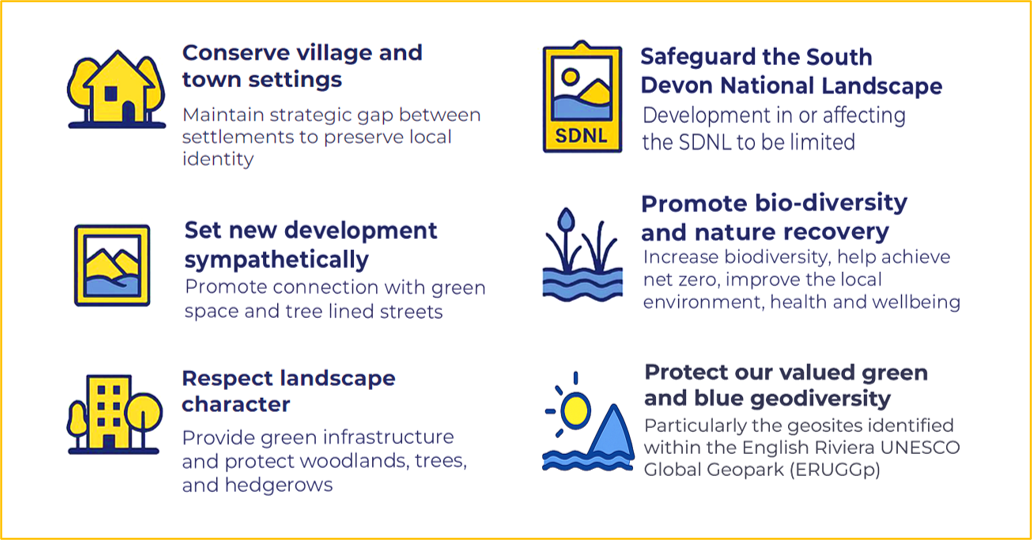
The overarching strategy is to provide a high-quality landscape setting and strong green infrastructure framework; to protect, conserve and, wherever possible, enhance landscape character and local distinctiveness for the countryside and seascape by reference to the Torbay Landscape Character Assessment, including the Historic Landscape Characterisation. The rural landscape performs a crucial part of the identity and value of our settlements and the strategic gaps between the three main towns in Torbay and between Torbay, Teignbridge and the South Hams should be protected to prevent coalescence and to retain the separate identities of the settlements.
The South Devon National Landscape (SDNL) has the highest status of protection and great weight will be given to conserving and enhancing the landscape and natural beauty; development within the SDNL setting should be sensitively located and designed to avoid or minimise adverse impacts on the designated area.
All new major development should be set sympathetically within the landscape, and promote a connection with green space and nature, providing appropriate green infrastructure including access to green space or water, such as ponds and streams; new streets should be tree-lined. Woodlands, trees and hedgerow features should be protected and provided appropriately to the scale of development and landscape context. Development should protect and enhance locally valued landscapes.
Urban open spaces and landscape/townscape features will be maintained or enhanced to support the overall character and appearance of the local environment.
Community and Corporate Plan – Pride in Place
Explanation
9.1The local landscape setting as a crucial part of the identity and value of Torbay. Conserving the setting of our villages, towns, and protecting the South Devon National Landscape, is a central consideration in approving or refusing permission for new development.
Strategic Policy L1: Protecting our countryside and rural economy View representations
In the open countryside away from existing settlements, and in rural areas surrounding the three towns of Torbay, development will be resisted where this would lead to the loss of open countryside or creation of urban sprawl, or where it would encourage the merging of urban areas and surrounding settlements to the detriment of their special rural character and setting. The countryside area (L1) and undeveloped coast (Policy L3) together define the settlement boundaries.
Major new development should focus on Future Growth Areas in the Strategic Delivery Areas set out in the Key Diagram, consistent with the ambition and policies of the Local Plan. Otherwise, development outside the main urban areas (as defined by the settlement boundary) and Strategic Delivery Areas will only be supported within the established boundaries of villages and hamlets, provided that it is of an appropriate modest scale and consistent with relevant Local Plan Policies, including those relating to landscape, recreation, biodiversity, design and conservation. Suitable infill development, refurbishments and conversions will be supported within these settlements in order to meet the day-to-day needs of local communities, to promote the retention and development of local services and to help maintain their sustainability. Village Envelopes in Maidencombe and Churston/ Galmpton are defined on the Policies Map.
Outside settlement boundaries, the following forms of development may be permitted, provided that the rural and landscape character, wildlife habitats, green corridors and historic features are not adversely affected and necessary mitigation measures are carried out to minimise any harm to the environment:
- New homes for which there is a proven agricultural need, or self-build affordable housing where acceptable under Policy H8.
- Development required for forestry, horticulture or agriculture;
- Touring caravans and tents;
- Tourist facilities appropriate to the rural area;
- Development associated with outdoor sport and recreation appropriate in a rural area;
- Sensitive conversion, alteration and extension of existing buildings;
- Essential improvements to the highway network; and
- Appropriate renewable energy development.
Where new development proposals come forward, the council will also have regard to the need to protect, conserve and enhance the distinctive landscape characteristics and visual quality of a particular location, as identified in the Torbay Landscape Study and Character Assessment, the suitability of development and the capacity of the countryside to accommodate change. Including dark skies, associated infrastructure such as parking should not overspill into surrounding countryside.
Proposals must demonstrate how they have taken into account the most recent Landscape Character Assessment and assessed the potential impact of the proposal on the landscapeincluding cumulative impact. Where a proposed development is likely to have a significant impact on the landscape character or visual amenity of an area, a Landscape Visual Impact Assessments (LVIAs) or Environmental Impact Assessment will be required.Policy L4 refers to locally valued landscapes.
Development in the countryside must not have an adverse effect on the integrity of the South Hams SAC or other important habitats. It should also have regard to Policy NC1 to assess the in-combination effects of multiple developments that could affect Greater Horseshoe Bats, calcareous grassland features and the integrity of the South Hams SAC, and the scope for developer contributions to mitigate the impact of increased recreational pressure on the South Hams SAC.
The Countryside Area is shown on the Policies Map.
Community and Corporate Plan – Community and Place
Explanation
9.2The open countryside of Torbay is a fundamental part of the sub-region’s identity and a major component of the Bay’s tourism offer. It provides amenity value and a range of recreational opportunities and is an integral part of the Bay’s economy.
9.3The Local Plan strikes a careful balance between protecting the integrity and character of the countryside whilst allowing development that is vital to the support of sustainable communities, such as rural exceptions affordable housing, and self-build schemes (see Policies H8 and H9) and the rural economy.
9.4The Countryside Area is shown on the Policies Map and has been defined for the following reasons:
- To identify the countryside around Torbay as a finite resource and to encourage its best use;
- To safeguard Torbay from further urban sprawl and maintain important green wedges;
- To prevent the main urban areas of Torbay from merging with each other and neighbouring settlements;
- To preserve the special character of the towns and villages within Torbay’s overall landscape setting;
- To recognise the need to adapt to changing demands in the countryside around Torbay and priorities for development;
- To concentrate building development within the urban area and prevent the unnecessary spread of inappropriate uses into the countryside; and
- To maintain a connected network of landscape features to provide Green Infrastructure
9.5Much of the rural hinterland will be covered by other designations including country parks other landscape designations as well as our best and most versatile agricultural land (Policy SC4). Proposals for development will be considered in the context of the Torbay Landscape Character Assessment which identifies the key characteristics to protect, conserve or enhance those features which contribute to a particular distinctive character.
9.6Different towns and urban areas in Torbay have very distinct identities that should be protected and wherever possible enhanced. Strategic green wedges are important to prevent urban coalescence and retain the valuable landscape setting that is characteristic of Torbay’s urban areas. About a quarter of the Countryside Area is also overlaid by the nationally important National Landscape (AONB) (Policy L2), and 40% is designated as undeveloped coast (Policy L3) and form part of the Strategic Local Nature Recovery Network (LNRN).
9.7The Local Plan Update provides an opportunity to identify areas of non-coalescence, on the Policies Map, which would seek to retain a rural and open character of the land, and/or protect the separate identity of settlements (both existing and allocated).
Policy L2: National Landscape (previous Area of Outstanding Natural Beauty)[16] View representations
Great weight will be given to conserving and enhancing the landscape and natural beauty of the South Devon National Landscape (previous Area of Outstanding Natural Beauty).
Major development in a designated National Landscape will be refused except in exceptional circumstances and where it can be demonstrated that it is in the public interest. Proposals within the setting of a National Landscape must not harm the setting and should be sensitively located and designed to avoid or minimise adverse impacts on the designated areas.
Consideration of such applications will assess:
- the need for the development, including in terms of any national considerations, and the impact of permitting it, or refusing it, upon the local economy;
- the cost of, and scope for, developing outside the designated area, or meeting the need for it in some other way; and
- any detrimental effect on the environment, the landscape and recreational opportunities, and the extent to which that could be moderated taking account of the relevant South Devon National Landscape (AONB) Management Plan and the special qualities alongside the Torbay Landscape Character Assessment.
Development which is permitted in the National Landscape should conserve and enhance its landscape and natural beauty, having particular regard to the impacts on its character components, as set out in the South Devon AONB Management Plan, including wildlife, cultural heritage, tranquillity, dark skies, views and avoids cumulative impacts; it should complement the scale, massing, footprint and spacing characteristic of the area. It should also adhere to guidance in the South Devon National Landscape (AONB) Management Plan, particularly in relation to the need for development to be landscape led building form and design. Mitigation measures may include planning contributions towards delivery of projects set out in the Management Plan.
Community and Corporate Plan – Pride in Place
Explanation
9.8National Landscapes (formerly known as Area of Outstanding Natural Beauty- AONBs) are designated in recognition of the outstanding qualities of their ‘natural beauty’ under the National Parks and Access to the Countryside Act 1949. They contain the most beautiful, spectacular, and dramatic areas of countryside and form landscapes of national importance with designation conferring the highest status for the conservation of landscape and scenic beauty.
9.9The Levelling Up and Regeneration Act (2023) amended Section 85 of the Countryside and Rights of Way Act 2000[1], which means that rather than ‘have regard to’, relevant authorities (including the Local Planning Authority) must ‘further the purposes’ of Protected Landscapes of conserving and enhancing the natural beauty[2] of the National Landscape (NL). Each component of natural beauty identifies what is special about the landscape and should be afforded ‘great weight’ in planning decisions. Reference to the South Devon National Landscape (SDNL) Management Plan is a key tool to ensure that public bodies are meeting their duty and reference to the special qualities which define the unique ‘natural beauty’ for which the SDNL is designated. The SDNL Management Plan’s policies and the special qualities (summarised below) of the SDNL establish criteria against which policy and actions can be assessed for compliance with the duty:
- Fine, undeveloped, wild and rugged coastline
- Ria estuaries (drowned river valleys), steep combes and a network of associated watercourses
- Deeply rural rolling patchwork agricultural landscape
- Deeply incised landscape that is intimate, hidden and secretive away from the plateau tops
- Iconic wide, unspoilt and expansive panoramic views
- A landscape with a rich time depth and a wealth of historic features and cultural associations
- Areas of high tranquillity, natural nightscapes, distinctive natural soundscapes and visible movement
- A breadth and depth of significant habitats, species and associated natural events
- An ancient and intricate network of winding lanes, paths and recreational routes
- A variety in the setting to the SDNL (AONB) formed by the marine environment
9.10The SDNL Management and Delivery Plan sets out externally funded projects and identifies the key planned actions delivered by partners that contribute towards the conservation and enhancement of the South Devon National Landscape. Where residual harm results from new development, mitigation measures may include a request for planning contributions towards achieving relevant projects.
Policy L3: Coastal landscape View representations
The undeveloped coast
The undeveloped coast is shown on the Policies Map.
The council and partnership organisations will conserve the character of the undeveloped coast and seek to enhance its distinctive landscape, seascape, biodiversity, geological, recreational and cultural value. Development will not be supported in the undeveloped coastal area unless proposals satisfy the following requirements:
- Maintain the unspoilt character of the coastline, coastal landscape and seascape;
- Maintain or improve public access for recreation; and
- Provide sensitively designed development, including tourism uses, where there are clear economic or sustainability benefits that cannot be realised in alternative locations.
Where new development proposals have met the above criteria, the council will also have regard to the need to protect, conserve and enhance the distinctive landscape characteristics and visual quality of a particular location, as identified in the Torbay Landscape Study and Character Assessment, the suitability of development and the capacity of the countryside to accommodate change and particular reference to coastal change management (Policy ER7).
Development outside the undeveloped coast which may harm the intrinsic character of the area will be assessed with regard to visual impact.
The Developed Coast
The developed coast: In the developed areas of coast, development will be permitted where it provides benefit to Torbay’s economy and does not unacceptably harm the landscape character and appearance of natural, historic or geological assets and coastal change management (Policy ER7).
Community and Corporate Plan – Pride in Place
Explanation
9.11Policy L3 deals with landscape and related matters to do with the coast. Policy ER7 Coastal Change Management Areas, deals with issues such as shoreline management, flooding and land stability which are associated with development in coastal areas.
9.12The mean low water mark defines the limits within which Torbay Council has a statutory power to control the development and use of land. The coast is significant from an environmental, economic and social perspective and adds greatly to the quality of life for Torbay’s residents. The scenic beauty, natural setting and seascape underpin Torbay’s popularity as a place to live, work and visit and so it is important to protect the intrinsic landscape character of the undeveloped coast for its own sake, and as a significant, finite resource. The quality of life and distinctive local identity is enhanced by a large number of accessible award-winning bathing beaches and three harbours, which form an important recreational and amenity resource. The South West Coast Path extends along Torbay’s coastline, providing an attractive environment for walking and wheeling which is a popular tourist draw.
9.13It is important that the qualities of the coastline are conserved for future generations, in particular the important areas of undeveloped coastline which extend landward to include areas that maintain a coastal character, and are within the visual envelope to and from the seaward side. Developments will only be permitted along the undeveloped coast to provide facilities for activities appropriate to the location, such as low-key rural tourism or recreation uses, where their introduction does not harm the scenic qualities and prevailing character, and any built development is kept to a minimum.
9.14Consideration should be given to whether there are alternative locations where the development could feasibly be located, away from the undeveloped coast. The Torbay Landscape Character Assessment (LCA) identifies a number of coastal landscape character types which incorporate the majority of the land within the undeveloped coast. The LCA should be used (in combination with any seascape analysis) as a basis for assessing the character and sensitivity of the area and its ability to accommodate new development. This will include parts of the developed coast where the LCA has identified ‘undeveloped’ maritime cliffs, open coastal plateau and low lying beaches, offshore islands and a new landscape type: Harbours, ports and marinas. Development should consider the valued landscape attributes and landscape guidelines.
Policy L4: Valued landscapes View representations
Landscapes which, by reason of their local distinctiveness, special qualities and features and or condition, that have a limited capacity to absorb change that will be considered to be valued landscapes.
This will include the South Devon National Landscape and its setting at a national level, alongside the undeveloped coast may be considered to form locally valued landscapes (LVL);
Proposals within these areas must:
- Avoid loss of key characteristics, or their legibility, that underpin the scenic quality and the significance of the locally valued landscape and landscape character area.
- Respond effectively to the key characteristics and significance of the area referred to in the Torbay Landscape Character Assessment and Landscape Sensitivity Assessments (2025) and the specific recommendations within the LCA (or subsequent update).
Locally valued landscape is not limited to the National Landscape and the undeveloped coast, and may be identified through the Torbay Landscape Character Assessment. Individual proposals within or next to these valued landscape areas should respond to the distinctive qualities and local character and will be assessed based on their specific landscape and visual impact taking into account any mitigation proposals.
Development which protects and enhances the locally valued landscapes will be supported.
Community and Corporate Plan – Pride in Place
Explanation
9.15There is no single definition of a valued landscape, however, legal decisions have tended to say that to be a ‘valued landscape’, there should be some local distinctiveness, special quality, or feature, rather than solely being ‘valued’ by local people. It will be a matter of planning judgement whether or not land forms part of a valued landscape, the council considers that the following are likely to qualify as valued landscapes which include but are not limited to: the South Devon National Landscape and its setting, undeveloped coast, land within or in the setting of a designated heritage asset, urban landscapes such as Local Green Spaces (LGS) and Urban Landscape Protection Areas (ULPAs).
9.16The LCA provides additional advice on whether areas of landscape are likely to be considered as ‘valued’.
Policy L5: Urban Landscape Protection Areas (ULPAs) View representations
Development within Urban Landscape Protection Areas (ULPAs), as shown on the Policies Map, will only be supported where:
- It does not undermine the value of the ULPA as an open or landscaped feature within the urban area; and
- It makes a positive contribution to the urban environment or enhances the landscape character of the ULPA.
Development that would undermine the ULPA designation as a whole will be resisted.
Designated Urban Landscape Protection Areas are as follows:
Table 18 Urban Landscape Protection Areas 17
|
Torquay |
|
01 Watcombe Park and Watcombe Heights |
|
02 Mincent Hill, Barton |
|
03 Scotts Bridge/Barton |
|
04 Riviera Way Corridor |
|
05 Lummaton Hill, Combe Pafford |
|
06 Hele Woods/Windmill Hill Woods |
|
07 Daison Woods |
|
08 St. Marychurch Road (formerly Oddicombe Downs) |
|
09 Babbacombe Downs |
|
10 Cary Park |
|
11 Markham Plantation and Sherwell Valley |
|
12 Shiphay Manor (Girls’ Grammar School) |
|
13 Rowcroft/Shiphay Plantation |
|
14 Chapel Hill, Torre |
|
15 Stantaway Hill, Upton |
|
16 Grange Road/Warberry Copse |
|
17 The Quinta |
|
18 Lydwell Road |
|
19 Palace Hotel Grounds (North) |
|
20 Palace Hotel Grounds (South) |
|
21 Ansteys Playing Field |
|
22 Ilsham Valley/Lincombe Slopes |
|
23 Torwood Gardens |
|
24 Daddyhole Plain |
|
25 St. Johns Wood, Park Hill |
|
26 Stentiford Hill |
|
27 Torre Abbey Meadows and Sports Grounds |
|
28 Sherwell Park |
|
29 Ashfield Gardens |
|
30 St. Matthew’s Field |
|
Paignton |
|
31 Preston Green |
|
32 Parkfield |
|
33 Paignton Green North |
|
34 Paignton Green South |
|
35 Queen’s Park |
|
36 Victoria Park |
|
37 Paignton Cemetery and allotments |
|
38 Monastery, Winner Hill |
|
39 Primley Woods and Meadow to south |
|
40 Goodrington Park/Roundham |
|
41 Quay West Corner |
|
42 Clennon Hill/Roselands Valley |
|
43 Sugar Loaf Hill |
|
Brixham |
|
44 Tor Rocks, Broadsands |
|
45 Brunel Woods, Galmpton |
|
46 Battery Grounds |
|
47 Furzeham Recreation Ground |
|
48 St. Mary’s Churchyard and Park |
|
49 Summercombe |
|
50 Shoalstone and Ashole Woods. |
Community and Corporate Plan – Community and Place
Explanation
9.17These enclaves of special landscape quality set in or bordering the urban areas (some of which also skirt the coastal fringe) vary in size and make a considerable contribution to the environment in a variety of ways. Taken as a whole these protected urban landscape areas form a valuable part of Torbay’s green infrastructure (see Policy GIS) and help ensure a healthy Bay (see Policy SC1). They are considered to form ‘valued landscapes’.
9.18Some ULPAs act as local vantage points, some as amenity open space, some as green spaces that provide a natural and visual break within the local (urban) townscape and others as landmarks in the local scene. In some cases they perform all four roles. Designated ULPAs include both publicly owned/publicly accessible and privately owned/non-accessible sites. Some ULPAs are also of ecological significance and some have been subsequently allocated as Local Green Spaces (LGSs) in Neighbourhood Plans.
9.19The preparation of an updated Local Plan offers the opportunity to review the designated ULPAs and provide further clarity and guidance in relation to these sites.
Policy L6: Local Green Spaces (LGSs) View representations
Development proposals that protect or enhance Local Green Spaces and that comply with other relevant policies will be permitted.
Development proposals that would have an unacceptable adverse impact on the use, function and appearance of these local green spaces or would result in their loss will not be permitted other than in very special circumstances and such circumstances will only exist where the harm resulting from the proposal is clearly outweighed by other considerations.
Very special circumstances may exist for development enabling community or sports use on LGSs used as playing fields, or café/ food and drink uses in Harbourside and Waterfront locations. In such instances to open nature of the wider LGS and public access should be retained.
Very special circumstances also cover the proposed railway station at Edginswell,
Development or change of use that would conflict with the reason for designation will be seen as inappropriate development.
Inappropriate development adjacent to a Local Green Space that would have a significant adverse impact upon the reason for the designation will not be supported.
Community and Corporate Plan – Community and Place
Explanation
9.20The Neighbourhood Forums have included a number of Local Green Spaces that are green spaces that are demonstrably special to a local community. Designation should be consistent with the local planning of sustainable development and complement investment in sufficient homes, jobs and other essential services and be capable of enduring beyond the end of the plan period. Local Green Space must be reasonably close to the community it serves; have demonstrable local significance and interest; be local in character; and not cover an extensive tract of land. Local Green Spaces are designated in the made (adopted 2019) Torquay Neighbourhood Plan (99 LGS see Policy TE2 - Local Green Spaces), Paignton Neighbourhood Plan (53 LGS - Policy PNP1 and PNP1(a)PGLS) and the Brixham Peninsula Neighbourhood Plan (17 LGS - Policy E4: Local Green Spaces).
9.21Consideration of development proposals within a Local Green Space should be consistent with national policy for Green Belts (excluding provisions relating to ‘grey belt’ and previously developed land).
Strategic Policy THS: Trees and hedgerows View representations
The Local Plan seeks to assist the delivery of the most up-to-date Torbay Tree Strategy. Planning applications will set out how they achieve the vision set out in the Devon Tree and Woodland Strategy to: Expand, Improve, Protect, Inspire and Deliver.
Development that supports the planting of new trees or areas of woodland, especially in appropriate Devon Local Nature Recovery Areas, or which would include public access woodland schemes, will be encouraged where they conserve or enhance biodiversity, landscape, seascape character and best and most versatile agricultural land, or where they conserve and where appropriate enhance the significance of heritage assets and their settings, including historic landscapes. All development proposals will retain good quality and healthy woodland, trees and hedgerows. These features will be incorporated into the overall design and landscape scheme and located within public spaces where possible (see Policy TH1). New streets should be tree lined unless there are compelling reasons why this would be inappropriate. Where loss is unavoidable, Policy TH2 would apply. The council will seek to adopt new public green spaces and may protect any new trees through the implementation of Tree Preservation Orders (TPO).
Ancient Woodland, Ancient Hedgerows and Veteran Trees:
Development proposals resulting in the loss or deterioration of ancient woodland, ancient hedgerows or ancient and veteran trees will only be permitted where there are wholly exceptional circumstances and the benefits of the development in that location clearly outweigh the loss. Where it is permitted, a compensation strategy will need to be agreed and secured prior to granting planning permission.
TPO/Conservation Area:
Where the proposal will result in the loss or deterioration of a tree protected by a Tree Preservation Order or a tree within a Conservation Area, then permission will be refused unless:
- the need for, and benefits of, the development in that location clearly outweigh the loss, and
- suitable and robust mitigation is provided through replacement tree planting or a suitable planning contribution
Trees elsewhere:
Any other tree, hedge or woodland not covered by the above and which makes a positive contribution to the landscape, amenity, heritage or biodiversity value of the area, should be retained as part of the design and layout of development schemes.
Where a loss of trees, hedges or woodland is unavoidable or justified through an arboricultural assessment, replacement planting commensurate with the loss will be undertaken on site. Tree planting will be in accordance with Policy TH2. Where onsite replacement tree planting is not feasible, developer contributions will be required.
In instances where new trees and/or woodlands are proposed as part of wider development proposals, developer contributions may be required to ensure suitable management provision is made for their long-term management. This includes information provision of for residents and users about the appropriate positive management of private trees and landscape features.
Community and Corporate Plan – Protecting and enhancing our natural environment
Explanation
9.22This policy aims to deliver strategic scale expansion of green landscape features and to ensure tree, woodland and other landscape features are protected, and where this is not possible suitable mitigation is provided.
9.23Woodlands, trees and hedgerows can form important landscape features as well as providing valuable habitats and wildlife corridors.
9.24Woodlands form traditional elements of the countryside or important islands of natural habitat within Torbay’s urban areas. Once lost, this part of our heritage cannot be replaced.
9.25Hedgerows, many of which are of traditional Devon Bank construction, are important elements within the landscape of Torbay. They can function as wildlife corridors linking wildlife sites. Hedges can also form very ancient land boundaries and may preserve historically important artifacts. A quarter of Devon’s hedges are more than 800 years old. For these reasons, it is important that significant hedgerows are retained and their appropriate retention will be secured by planning conditions.
9.26Established hedges have substantially more historic and environmental value than new hedges, which take time to mature and do not reflect historic enclosure patterns. Therefore, existing hedges should be retained wherever possible. This is particularly important where they form part of Greater Horseshoe Bat commuting routes identified in Policy NCS2. Maintenance of hedgerows may be essential to maintain the integrity of the South Hams SAC and must be considered at an early stage of the planning process, in accordance with Policies NCS2 and NC1.
Policy TH1: Trees, hedgerows and natural landscape features
Development will not be permitted where it would result in serious harm, either directly or indirectly, to protected trees, veteran trees, hedgerows, ancient woodland, unless it is clearly demonstrated that the harm is justified and can be appropriately avoided, minimised or mitigated. Harm can arise directly, through felling or damage during construction, or indirectly through pressure to fell or prune in the future due to the proximity of trees to a new development.
In applying this policy, regard will be had to the hierarchy of protection set out in Strategic Policy THS. Other natural features of significant landscape, historic or nature conservation value are addressed in Policies LS, L4 and NCS1.
Where loss of trees, hedgerows or woodland is justified under Strategic Policy THS, appropriate mitigation will be required in accordance with this policy and Policy TH2, which may include developer contributions to secure long-term management and maintenance.
Development proposals should seek to retain and protect existing hedgerows, trees and natural landscape features wherever possible, particularly where they serve an important biodiversity or climate resilience role.
All development proposals will demonstrate how retained and new trees, hedges and woodland will have a satisfactory long-term relationship with: buildings; infrastructure; utilities and services; and highway movement; and will ensure the amenity and safety of occupiers of buildings and retain or create sightlines enabling public spaces to be well overlooked.
Planting schemes for public spaces and roadsides should include suitable native species that occur naturally in the locality, unless it can be demonstrated that native species are not appropriate (e.g. for arboricultural or ecological reasons). In accordance with Policy DE1, ‘Living’ boundary features should be used as an integral part of layouts in the first instance and must comprise native hedging species wherever possible.
New development will be designed and undertaken to prevent damage to root systems of retained or new woodland, trees and hedgerows and will allow for future above and below ground growth over the life of the development. New trees must maximise their potential to provide climate resilience, including surface water attenuation, through measures such as tree pits which are fully integrated to SuDS schemes.
Measures to protect retained trees, hedges and woodland must be in place before, and remain in place during, the development process. This must be demonstrated through an agreed Method Statement. Appropriate management will be secured in perpetuity, through agreed Landscape Management Plans. For major residential developments, this should include the provision of information for new occupants about the benefits of and appropriate positive management of private trees, hedges and landscape features.
Where building near trees or hedges is unavoidable, construction techniques and methods of working will be designed to prevent or minimise damage. Temporary netting of hedges or trees prior to, and during construction of, development will not be permitted. Where hedges cannot be retained, they should be translocated, rather than removed.
Community and Corporate Plan – Protecting and enhancing our natural environment
Explanation
9.27Trees provide significant environmental benefits and are especially valuable in urban areas. Beyond their intrinsic beauty, they help soften the impact of development, enhance the quality of our streets, and create a green framework for towns. Trees can be important both individually and in groups, and in some parts of Torbay, they are a defining feature of the local character.
9.28Orchards form an important part of green infrastructure and local heritage, as well as supporting sustainable food production. Traditional orchards are a priority habitat, and the Council has a statutory duty to conserve and enhance such habitats. Proposals affecting orchards will be assessed against Policies GIS, THS, and SC4.
9.29Trees can be perceived negatively when located close to properties, where they can obstruct views, reduce light, or create maintenance and safety concerns. Development will not be supported if it is incompatible with the retention of trees. Proposals affecting trees will be carefully considered to ensure trees which are to remain do not cause unreasonable inconvenience to future occupiers.
9.30Construction can easily damage tree roots through compaction or excavation. When determining planning applications, it is essential to ensure that construction activities do not occur in close proximity to trees in ways that could cause harm.
9.31Trees will be safeguarded through planning conditions attached to development consents. These conditions may specify measures to protect trees during and after construction. Such conditions will be applied wherever trees of amenity value are adjacent to development. New planting should aim to enhance existing habitats, create new ones, or provide shelter belts.
9.32Tree Preservation Orders (TPOs) may be used to protect trees of amenity value and prevent their removal. TPOs can apply to individual trees, groups, or entire areas. Torbay benefits from a rich legacy of trees, many of which are already protected by TPOs. Similar protections apply to trees within conservation areas, where there is generally a presumption against felling unless there are sound reasons for doing so.
Policy TH2: Mitigation for loss of trees, hedgerows and woodland View representations
Where the principles of Strategic Policy THS have been followed, and it is evidenced that the loss of trees, hedgerows or woodland is acceptable, appropriate mitigation will be required.
Tree loss should be mitigated through compensatory planting in accordance with the Council’s tree replacement table below.
Hedgerow loss should normally be replaced on at least a metre‑for‑metre basis, with a preference for achieving a net gain in connectivity and ecological value.
Where relevant, mitigation for the loss of trees and hedgerows may contribute towards Statutory Biodiversity Net Gain (BNG) (Policy NC3). Where BNG does not apply, tree and hedge mitigation should be secured separately.
In exceptional circumstances (e.g. where on-site mitigation would compromise good design), off-site provision or financial contributions may be accepted.
Deliberate prior removal of trees will be a material consideration.
Such tree planting should:
- take all opportunities to meet the five Tree Planting Principles (see supporting text); and
- unless demonstrably impractical or inappropriate, provide the following specific quantity of compensatory trees for the loss each tree within the size category indicated in the Tree Loss Compensation table below.
Table 19 Tree Loss Compensation
|
Trunk girth (mm) at 1.5m above ground of tree lost to development |
Number of replacement trees required per tree lost* |
|
75 - 200 |
2 |
|
201 - 400 |
4 |
|
401 - 600 |
6 |
|
601 - 800 |
9 |
|
801 - 1000 |
10 |
|
1000+ |
11+** |
* Replacement based on selected standards 100-120 mm girth at 1.0m
**Depending on the value of the tree to be lost additional compensatory planting may be required
An equivalent approach based on the latest Natural England’s Green Infrastructure Framework Standards may be considered as mitigation where appropriate.
Where new compensatory hedges are provided, the principles of the Devon Hedge Group guidance on making new hedges should be followed unless an alternative approach is justified by site-specific circumstances.
In instances where new trees, hedges and/or woodlands are proposed, developer contributions may be required to ensure suitable provisions are in place for their long-term management and maintenance.
Community and Corporate Plan – Protecting and enhancing our natural environment
Explanation
9.33rees and other planting deliver a wide range of benefits, including wildlife habitat, urban cooling to help address climate change, adding maturity to new developments, softening and enhancing built form, providing screening and shade, reducing stormwater run-off, improving visual amenity, and supporting health and well-being.
9.34New trees and planting can contribute to the government’s 25 Year Environment Plan, the UK’s efforts to hit net zero carbon emissions by 2050, biodiversity net gain and the Devon Tree and Woodland Strategy goal of achieving 20% tree cover in Torbay.
9.35The tree and hedgerow compensation standard in this policy provides an indicative mechanism to determine the appropriate level of mitigation for loss of trees and hedgerows. Mitigation will be determined on a case-by-case basis in consultation with the Council’s tree officer. The council’s preference is for on-site replacement in suitable locations, secured through planning conditions however, for small scale householder development, off-site mitigation may be more appropriate.
9.36Where off-site planting is justified, this should be preferentially be provided on public land or locations identified through the Devon Local Nature Recovery Strategy and will be secured via planning obligations.
9.37Replacement planting and hedgerow creation required under this policy provide mitigation for the loss of existing features and are separate from statutory Biodiversity Net Gain requirements. While such measures may contribute towards Biodiversity Net Gain and assist compliance with Policy NC3, they do not remove the need to provide mitigation required under this policy. The requirements of this policy will continue to apply to development that is exempt from Biodiversity Net Gain requirements.
9.38The council is committed to increasing the overall tree cover wherever possible. Opportunities for new tree planting should be explored in all development proposals. Planting schemes for public spaces and highways should include only native species that occur naturally in the locality, unless arboricultural or other considerations mean native species are not appropriate.
9.39Where new tree planting is proposed (whether to compensate for losses on- site or as enhancement), the quantity, location and species selection of new trees will be expected to take practicable opportunities to meet the following five Tree Planting Principles:
- Create habitat and, if possible, connect the development site to the Strategic Green Infrastructure Network; and
- Assist in reducing or mitigating run-off and flood risk on the development site; and
- Assist in providing shade and shelter to address urban cooling, and in turn assist in mitigating against the effects of climate change; and
- Create a strong landscaping framework to either (a) enclose or mitigate the visual impact of a development or (b) create new and enhanced landscape, or both; and
- Be of an appropriate species for the site.
Strategic Policy NCS1: Biodiversity and Nature Recovery Network View representations
All development for the purposes of conservation and enhancement of the natural assets within the Bay will be supported.
The council will safeguard, conserve and enhance the valued qualities, features and attributes of sites in the Bay which are important for biodiversity and geodiversity.
In order to increase biodiversity, help achieve net zero, improve the local environment and enhance health and wellbeing, all development will be required to:
- Recognise the importance of and benefits provided by ecosystem services, and be located and designed to avoid negative impacts on biodiversity and geodiversity. This includes but is not limited to tranquillity, dark night skies, bathing waters, biodiversity, geodiversity and soils within the Bay (commensurate with their importance). Only where this is not possible will mitigation, and as a last resort, compensation be considered.
- Protect, enhance and expand existing wildlife-rich habitats and geodiversity, and create new ones to support a nature recovery network. Development must seek to support and deliver the priorities and actions in the most up to date Torbay Green Infrastructure Strategy, Nature Recovery Network (NRN) and Devon, Plymouth and Torbay Local Nature Recovery Strategy (LNRS). These strategies must be utilised to ensure new development integrates wildlife and links new green spaces with habitats in the wider landscape.
- Protect local, national and internationally protected sites, priority species and habitats. The council will safeguard, conserve and enhance the valued qualities and features of sites protected under European legislation, including supporting habitats outside of the designation which ensures the favourable conservation status of the site. Where a proposal may have adverse effects on a European site which cannot be mitigated development will not be permitted. Particular attention must be paid to Greater Horseshoe Bat flight paths, and Cirl Buntings.
- Avoid impacts on irreplaceable habitats. Development that involves the loss of irreplaceable habitats will not be supported.
- Positively incorporate and promote biodiversity features, proportionate to their scale, including features which support priority or threatened species such as swifts, bats and hedgehogs.
- Provide a measurable and proportionate net gain in biodiversity, as set out in Policy NC2.
- Provide long term land management practices to maintain or restore landscapes, greenspace, watercourses, dark corridors and amenity open spaces, integrating biodiversity and green infrastructure objectives including improved public access.
- Have regard to the Devon, Plymouth and Torbay Local Nature Recovery Strategy and, where proportionate, seek to support the delivery of its priorities, including by contributing to habitat restoration, enhancement and creation within identified High Opportunity Areas.
All development must be located and designed to follow the mitigation hierarchy (avoid, minimise, mitigate, compensate) to prevent adverse impacts upon biodiversity, or geodiversity. Developer contributions may be required to allow monitoring of any mitigation, or to improve management or enhancement of the natural environment.
Community and Corporate Plan – Protecting and enhancing our natural environment
Explanation
9.40Biodiversity is fundamental to our health, wellbeing, and economic prosperity. ‘Biodiversity’ means the variety of wild plants, animals, and their habitats, and also includes geological and geomorphological features. A healthy, resilient natural environment is a key asset for Torbay, contributing to its sense of place, tourism appeal, economy, and overall environmental quality. Biodiversity is also an essential consideration in achieving high-quality design.
9.41The importance of biodiversity is increasingly recognised by government, reflected in the Environment Act 2021 and the 25 Year Environment Plan. Torbay contains internationally, nationally, and locally designated nature conservation sites, shown on the Policies Map, which support a wide range of species. In 2024, the Torbay Climate Partnership approved the Greener Way for Our Bay Framework and Action Plan (GWFOB), which sets out a pathway for Torbay to achieve net zero carbon by 2050. The framework identifies ten key priorities, including “enjoying and protecting our marine and natural environment.” The nature conservation policies within this Local Plan align with the objectives of the GWFOB and will play an important role in supporting its delivery, particularly through the protection and enhancement of biodiversity and designated sites.
9.42The Devon Local Nature Recovery Strategy (LNRS) forms part of the evidence base for this Plan. Development proposals should have regard to the Devon, Plymouth and Torbay Local Nature Recovery Strategy and any local biodiversity evidence relating to target habitats and species. The Council will have regard to the LNRS priorities and mapped High Opportunity Areas when planning for biodiversity conservation, enhancement and recovery.
9.43Landscape, biodiversity, and green infrastructure mitigation packages will be informed by these strategies and evidence. The Council will require no overall detriment and will seek net gains for the natural environment in line with the NPPF. Policy. Mitigation cannot compensate for intrinsically unsuitable development (see Policy NC1). High-quality bathing waters are also a key ecological and tourism asset; Policies ER2, ER3, and W5 aim to minimise wastewater impacts, including restricting new surface water connections to combined sewers.
9.44Landscape can also be man-made and there is an interrelationship between the historic and natural environment for example when considering hedgerows, field patterns and other naturalised features (see Policies GIS and HES).
Strategic Policy NCS2: Habitats Regulations Assessment View representations
Development must not adversely affect the integrity of sites protected under the Conservation of Habitats and Species Regulations 2017 as amended[17] (European Sites), other than in exceptional circumstances.
Sufficient and up-to-date survey information, commensurate with the sensitivity of the site and the nature, location, and scale of the proposal, will be required to inform planning applications and allow the planning authority to carry out Habitats Regulations Assessment (HRA) of the proposal.
Where likely significant effects on a European site cannot be ruled out, either alone or in combination with other plans or projects, an Appropriate Assessment will be required. Permission will only be granted where the competent authority can ascertain that the proposal will not adversely affect the integrity of the habitats site, having regard to its conservation objectives. Mitigation relied upon to support a conclusion of no adverse effect on integrity must be certain, deliverable, enforceable, funded, monitored, and secured before planning permission is granted, for the full duration of the impact.
Where adverse effects on integrity cannot be ruled out, permission will only be granted where the derogation tests in the Habitats Regulations are met (see glossary).
Plans and proposals should take into consideration and be in accordance with the latest versions of all council and wider HRA guidance documents and strategies. Specific HRA policy requirements in relation to avoiding, mitigating andcompensating impacts on European sites (at the point of Local Plan publication) are set out in the HRA Requirements Table below.
Table 20 Habitats Regulations Appropriate Assessment (HRA) Requirements
|
Habitats Regulations Appropriate Assessment (HRA) Requirements |
|
|
Protected Site and features |
HRA Requirements |
|
Berry Head to Sharkham Point component of the South Hams SAC: Vegetated sea cliffs of the Atlantic and Baltic coasts European dry heaths Semi-natural dry grasslands and scrubland facies: on calcareous substrates (Festuco brometalia |
A strategic mitigation approach applies to recreation pressure on the sensitive habitats making up the Berry Head to Sharkham Point component of the South Hams SAC. Development within the identified Zone of Influence that would increase recreational pressure, including residential and tourist accommodation, will be required to contribute to or provide mitigation in accordance with the latest mitigation strategy and supporting guidance. In most cases, mitigation for new residential or holiday accommodation within the Zone of Influence (ZoI) will comprise a financial contribution towards measures identified through the Council’s latest mitigation strategy and, where required, Appropriate Assessment. These may include: Strategic Access Management and Monitoring Measures, provision or improvement of alternative local greenspaces, local access management projects, visitor management, monitoring, wardens, education, or other measures identified through Appropriate Assessment. Where major schemes are likely to result in a significant increase in recreational pressure at Berry Head, specific on-site measures, alternative recreation facilities, or other bespoke mitigation may also be required. Any deviation from the strategic mitigation approach must be clearly justified and will be considered on a case-by-case basis. |
|
Berry Head to Sharkham Point component of the South Hams SAC: South Hams SAC Greater Horseshoe Bats |
Development that could impact Greater Horseshoe Bats will be located and designed to protect the integrity of the South Hams SAC by:
Core sustenance zone additional requirements Within the Core Sustenance Zone, avoidance of impacts to Greater Horseshoe Bat habitat and connectivity will be prioritised over mitigation, compensation or enhancement measures. Within the Core Sustenance Zone (CSZ), development resulting in the loss, fragmentation, degradation or illumination of Very High or High suitability habitat for GHBs (see glossary) will not be permitted where GHBs are known to forage unless it can be demonstrated through project level HRA that habitat function and connectivity will be maintained and a net gain in GHB foraging habitat can be secured elsewhere within the CSZ. Development on areas of Low suitability habitat surrounded by or adjacent to Very High or High suitability habitat will not be permitted where it would adversely affect the function or connectivity of the surrounding habitats. Within the Core Sustenance Zone (CSZ), development impacting contiguous Low suitability habitat for GHBs must demonstrate that GHB habitat function is maintained and there is no overall reduction in habitat extent or functional connectivity across the CSZ and connectivity to the wider SZ and LCZ is safeguarded. Pinch Point additional requirements Within identified pinch points and commuting corridors, development will only be permitted when it can demonstrate that the functional continuity of the Pinch Point is maintained (see explanation). Mitigation/monitoring Within the CSZ, habitat, pinch point or commuting corridor loss, disturbance or illumination will only be permitted in exceptional circumstances. In such cases, replacement features must be secured in advance on a like-for-like or better basis and designed to maintain ecological function, prey availability and connectivity, ensuring there is no overall loss of GHB foraging habitat or network function. Elsewhere within the SZ and LCZ, where impacts cannot be avoided, appropriate mitigation, habitat enhancement, roost provision and/or financial contributions will be required. All measures must be secured before permission is granted, monitored for effectiveness and include remedial action where necessary. |
|
Lyme Bay and Torbay Marine SAC |
Water Quality: In respect of the Lyme Bay and Torbay Marine SAC the council has commissioned a Water Cycle Study and a Sewer Capacity Assessment. This evidence sets out the measures required to ensure there are no cumulative adverse impacts on the Marine SAC resulting from combined sewer overspills (CSO). Mitigation for CSO increase and the removal of surface water from the combined sewer system is set out in detail in Policies ER2, ER3, ER4 and will comprise:
Additional mitigation for surface water runoff will be provided through the implementation of Policy GIS ‘Strategic Green infrastructure’. Lyme Bay and Torbay Marine SAC Is also sensitive to changes in water quality arising due to the construction/operation of development. This typically includes, but is not limited to, major development or demolition located within 250m of the designated site, or near a watercourse which provides a hydrological link to the Lyme Bay and Torbay SAC. Where there is a risk of adverse effects on the Lyme Bay and Torbay SAC due to water quality, development proposals must prepare and submit, as part of a planning application, Pollution Prevention Plans. Recreation: Individual planning applications that have a clear link to increased recreational use of the coast will be subject to project-level HRA, and a bespoke package of measures will need to be secured to address the specific impacts of the proposed project. |
Community and Corporate Plan – Protecting and enhancing our natural environment
Explanation
9.45As a Competent Authority, the planning authority must carry out Habitats Regulations Assessments (HRA) in accordance with the Conservation of Habitats and Species Regulations 2017 (as amended). Torbay currently contains two internationally important habitats sites: the South Hams SAC and the Lyme Bay and Torbay Marine SAC.
9.46 All plans and projects not directly connected with the conservation management of a habitats site require HRA Screening to assess potential significant effects. Where significant effects cannot be ruled out, an Appropriate Assessment must be undertaken. Planning permission can only be granted where adverse effects on site integrity are excluded, or where there are imperative reasons of overriding public interest and adequate compensatory measures are secured.
9.47Sites protected under the Conservation of Habitats and Species Regulations 2017 consist of:
- Special Areas of Conservation (SAC);
- Special Protection Areas (SPA);
- Proposed SACs;
- Potential SPAs;
- Areas secured as sites compensating for damage to a European site.
9.48In addition to the Local Plan, the Council has prepared HRA guidance documents and strategies to support a consistent strategic approach to mitigation and reduce unnecessary duplication in assessment. Plans and projects should have regard to these documents, where relevant, alongside applicable Natural England guidance.
9.49South Hams SAC: The Berry Head to Sharkham Point component of the South Hams SAC forms part of the UK’s national site network and is designated for its heathland, calcareous grassland, vegetated sea cliffs and caves. These habitats are of importance for conservation at a European level and are listed under Annex I of the Habitats Directive (Council Directive 92/43/EEC). Berry Head is also designated as a Site of Special Scientific Interest (SSSI) and National Nature Reserve. The habitats at Berry Head are vulnerable to degradation through erosion by walkers and eutrophication through dog fouling, in addition to scrub encroachment.
9.50A visitor survey in 2023 found that 75% of visitors to Berry Head came directly from home within 8 km of the site, compared to 5 km in 2016. This indicates that the primary Zone of Influence (ZoI) for recreational impacts on Berry Head is an 8 km radius (Figure 21).
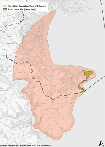
9.51Significant effects from increased recreation due to the development of housing or tourist accommodation within the Zone of Influence (ZoI) cannot be ruled out and mitigation measures will be necessary.
9.52The council, in collaboration with stakeholders, will develop a detailed Berry Head Management Plan including mitigation measures and associated cost estimates. A Supplementary Planning Document (SPD) or planning guidance note will set out the mitigation costs and the mechanism for securing developer contributions.
9.53The South Hams SAC is also designated for Greater Horseshoe Bats (GHB), one of Britain’s rarest bat species. Greater Horseshoe Bats use hedgerows (including remnant hedges and veteran trees) as flyways.
9.54Greater Horseshoe Bats have only short-range echolocation, which means they must fly close to the ground and linear features, such as hedges, woodland edges, and vegetated watercourses. They actively avoid light levels above moonlight. As a result, development must protect natural features that provide landscape connectivity and avoid lighting that deters bats. The bats use a variety of different roosts at different times of the year, including maternity and hibernation roosts. They feed in different habitats throughout the year, depending on seasonality of prey, typically foraging up to 4km from the roost as an adult. This 4km radius is used to determine the “Sustenance Zones” around roosts, although they will travel further when moving between different roosts. Juveniles typically only forage within 1 km of the roost in their first summer, so foraging habitat close to maternity roosts is particularly important. Hibernating bats are known to feed less frequently and within shorter distances during winter months.
9.55The Torbay Greater Horseshoe Bat Evidence Study (2026) found that the Berry Head roost is constrained by the sea, the built-up area of Brixham and a limited number of commuting routes. The study identifies a Core Sustenance Zone around the roost, together with areas of Very High, High and Low suitability habitat, to reflect their relative importance to the SAC bat population. Within the Core Sustenance Zone, maintaining habitat extent, quality, connectivity and dark commuting routes is particularly important. The study found that habitats close to the roost and key commuting corridors make a disproportionate contribution to maintaining the integrity of the South Hams SAC population.
9.56The study also identified a series of pinch points where commuting routes are constrained by existing development, topography or other barriers. These areas are especially sensitive to further habitat loss, severance or illumination because there may be limited alternative routes available to Greater Horseshoe Bats.
9.57The council has jointly adopted the South Hams SAC Habitats Regulations Assessment Guidance. The guidance assists those submitting planning applications for development that could have an adverse effect on the integrity of the South Hams SAC Greater Horseshoe Bat population. The document identifies a Consultation Zone which includes roosts, Sustenance Zones, Landscape Connectivity Zone, pinch points and existing mitigation features required for previous developments.
9.58Changes in land management or habitat condition affecting habitat used by Greater Horseshoe Bats may be a material consideration in the assessment of planning applications and Habitats Regulations Assessment. The deliberate degradation, fragmentation or alteration of habitat which supports, or is likely to support, the South Hams SAC Greater Horseshoe Bat population, including changes to grazing management, may be taken into account in decision making.
9.59 The Lyme Bay and Torbay Marine SAC:Torbay has a rich marine environment with its coastal waters designated as both a Marine SAC and a Marine Conservation Zone (MCZ). The Torbay component of the Marine SAC includes reefs and sea caves, supporting a variety of marine life. The MCZ protects nine different marine habitats which include seagrass beds and the intertidal area.
9.60The features of the Marine SAC and the MCZ are sensitive to changes in water condition/quality. Sewer spills and sewer flooding must be avoided. Pollution from surface water run-off—such as oil, chemicals, and other contaminants—during construction and operation phases can have cumulative negative impacts on water quality and coastal species. Discharges of pollution from the land may alter physicochemical conditions of coastal waters, including temperature, turbidity, salinity, and nutrient levels, affecting designated features.
9.61The Local Plan includes measures to reduce the impacts of development on coastal waters and minimise sewer outfalls, particularly at Hopes Nose, Torquay. Relevant policies include ER1, ER2, ER3, ER4, W5, and GIS. Measures may include planning contributions to deliver additional mitigation for surface water runoff for key watercourses.
9.62The SAC Sea caves are unique within the UK and contain very sensitive fauna that are vulnerable to damage. Risk of damage of damage can arise due to recreational activities such as wild swimming, kayaking, paddleboarding, personal watercraft use, diving, coasteering, and shoreline access at low tide.
9.63 At present the SAC sea caves are recorded as being in Favourable condition. There is no evidence currently available to conclude that recreational activities are damaging the SAC features, or that recreational activities are attributable to the housing numbers identified in the Local Plan. Individual planning applications that have a clear link to increased recreational use of the coast will need to be subject to project-level HRA, and a bespoke package of measures will need to be secured to address the specific impacts of the proposed project.
Policy NC1: Biodiversity and ecology View representations
Part 1: Protection of internationally and nationally important wildlife sites
Internationally and nationally important sites and species will be protected. Development proposals must undertake a thorough assessment of impacts on internationally and nationally important sites (both individually and in combination with other developments) and must avoid impacts in the first instance. Development that enhances internationally and nationally important sites will be supported.
Development proposals that would cause a direct or indirect adverse effect upon internationally and nationally designated sites will not be permitted unless it is demonstrated that all the following criteria are met:
- Alternative sites have been considered, and the development cannot be located on an alternative site that would cause less or no harm.
- The proposal cannot be achieved through an alternative, less harmful design or form.
- Suitable avoidance and mitigation (and exceptionally compensation) measures are proposed, in accordance with the mitigation hierarchy.
- In respect of European sites, the effects can be fully mitigated and the integrity of the site will be maintained.
- The public benefits of the proposal clearly outweigh the harm.
- Where permanent or long-term temporary habitat loss or direct reduction of habitat condition is identified, bespoke compensation measures will need to be agreed. This must be undertaken as early as possible and include utilisation of the Discretionary Advice Service from Natural England.
Development likely to affect an international site will be subject to assessment under the Habitat Regulations. Currently there two European designated sites within the Torbay boundary, the South Hams SAC and the Lyme Bay and Torbay Marine SAC.
Internationally and nationally important designations are listed in detail in Appendix D.
Part 2: Protection of regionally and locally important wildlife sites and features
Development which conserves, restores or enhances regionally and locally important wildlife-rich sites, networks, priority habitats and geodiversity will be supported.
Development proposals that would cause a direct or indirect adverse effect upon the above will not be supported unless the following three criteria are met:
- They cannot be located on alternative sites that would cause less or no harm. Every effort has been made to minimise any damage.
- The public benefits of the proposal clearly outweigh the impacts on the features of the site, the wider network of natural habitats and designated sites
- Suitable avoidance, mitigation and compensation measures are proposed, in accordance with the mitigation hierarchy.
Developments should provide an assessment of biodiversity value. This should particularly include any features that have previously been identified that would support designation as a County Wildlife Site or Regionally Important Geological Site and measures to conserve and enhance them.
Community and Corporate Plan – Protecting and enhancing our natural environment
Explanation
9.64Statutory designated wildlife sites benefit from substantial protection under national legislation. This policy does not duplicate these protections but provides additional detail on permissible impacts and biodiversity enhancement expectations.
9.65International and nationally important sites falling under this policy include:
- Special Areas of Conservation (SAC)
- Special Protection Areas (SPA)
- Proposed SACs
- Potential SPAs
- Ramsar sites
- Areas secured as compensation for damage to an internationally or nationally designated site
- Sites of Special Scientific Interest (SSSI)
- Marine Conservation Zones (MCZ)
- National Nature Reserves (NNR)
9.66Regionally and locally important wildlife and geological sites include:
- Local Nature Reserves (LNR)
- County Wildlife Sites (CWS)
- Other Sites of Wildlife Interest (OSWI)
- Regionally Important Geological Sites (RIGS)
- Special verges
- Habitats of Principal Importance, as listed under Section 41 of the Natural Environment and Rural Communities (NERC) Act 2006 (identified through site survey work or as identified through existing mapped resources)
9.67The NPPF requires local plans to identify and map sites of international, national and local importance and to follow the mitigation hierarchy: avoid harm where possible, mitigate impacts where unavoidable, and compensate for harm only as a last resort. Where harm involves protected species of European significance, it must be noted that compensation can only be considered where it can be shown that the development proposal is in the national interest.
9.68Torbay supports both European and UK protected species, as well as UK priority habitats. Notably, Torbay hosts a large population of Cirl Buntings—one of Britain’s most endangered songbirds. Targeted conservation has increased their numbers, and guidance on safeguarding this species has been produced by Devon County Council and the RSPB (November 2014). Development must protect Cirl Bunting habitats directly or contribute to offsetting through provision of receptor habitats.
9.69Torbay also supports populations of bat species, reptiles, seabirds and seahorses, which are protected under legislation including the EU Habitats Regulations and the Wildlife and Countryside Act 1981, as well as local frameworks such as County Wildlife Sites. Torbay also has several areas of ancient woodland that form an irreplaceable biodiversity resource both for its diversity of species and for its longevity as woodland. Veteran or aged trees outside ancient woodland are also particularly valuable. Irreplaceable habitats should be protected; to be acceptable, development would clearly need to outweigh any harm.
9.70Torbay’s coastal waters are designated as the Lyme Bay and Torbay Marine Special Area of Conservation (SAC) and as a Marine Conservation Zone (MCZ). These areas support reefs, sea caves, and diverse marine life. The Local Plan requires development to minimise impacts on sewer outfalls, particularly at Hopes Nose, Torquay. Sustainable urban drainage systems (SuDS) and water-sensitive urban design are promoted through Policies ER1, ER2, ER3, and W5.
9.71 The council will seek to improve Torbay’s biodiversity and geodiversity, including increasing the number and proportion of Local Wildlife Sites (CWS and RIGS) in ‘positive management’. This could include enhancing the status of Proposed and Unconfirmed Wildlife Sites (UWS). The Council will therefore seek to gain appropriate protection and recognition for locally important sites commensurate with their importance. Development should be located to minimise its impact on biodiversity. Development should follow the mitigation hierarchy - where impacts occur, mitigation and/or compensation will be required. Measures such as strengthening of flight paths, corridors, appropriate planting of biodiversity-rich species, the creation of habitats and biodiversity management programmes will be required through planning condition or s106 Planning Obligations. Biodiversity impact is an on-site acceptability matter and cannot be avoided to improve scheme viability.
9.72 New development should maximise opportunities to incorporate wildlife features through landscaping and design; this may include artificial bird nesting and bat roosting sites/boxes.
9.73 A schedule of Torbay’s SSSIs, National Nature Reserves and Local Sites of Wildlife and Geological Interest is set out in Appendix D. The Local Plan Policy NC2 supports the RSPB’s aspiration for an average provision of one new bird or bat box per new dwelling.
Policy NC2: Species of principal importance View representations
Development proposals that would have an adverse impact on European Protected Species (EPS), Nationally Protected Species, Section 41 Priority Species, or Devon Local Priority and Special Species will not be supported.
Particular regard must be given to potential impacts on Cirl Bunting habitats and territories. Development affecting Cirl Buntings will only be permitted where the benefits of the proposal clearly outweigh the impacts, including cumulative effects, and where those impacts can be fully mitigated.
Development must reflect species-specific guidance, including the Devon Local Nature Recovery Strategy and the most up-to-date Torbay Green Infrastructure Strategy.
All development should incorporate opportunities to enhance habitats for Protected and Priority Species within the built environment in addition to features required as part of biodiversity net gain, mitigation or compensation. This may include features such as bird, bat and invertebrate boxes, swift bricks, bee bricks, and hedgehog holes and permeable boundaries.
Enhancement provision should be proportionate to the scale of development. As a minimum guide, the following should be provided per dwelling or per 100 sqm of non-residential floorspace as a minimum, in suitable locations:
- 2-4 integrated bird boxes such as swift bricks
- 1-2 bat boxes
- 1 bee brick
Where appropriate, a monitoring scheme must be agreed and secured prior to granting planning permission. This should ensure mitigation measures are implemented effectively and include any necessary remedial actions.
Community and Corporate Plan – Protecting and enhancing our natural environment
Explanation
9.74A wide range of species are protected under international and national legislation both within and outside designated protected habitats. In Torbay, European Protected Species include bats, hazel dormouse, and great crested newt. UK Protected Species include Cirl bunting, barn owl, and Deptford pink.
9.75Species listed as of Principal Importance under Section 41 of the Natural Environment and Rural Communities Act 2006 are also protected through national planning policy. The list includes over 800 species such as hedgehog, skylark, and brown hairstreak butterfly.
9.76The Devon Local Nature Partnership has identified approximately 1,600 species considered rare in Devon (Devon Priority Species), along with a list of 96 species known as Devon’s Special Species, for which the county has a particular conservation responsibility, including the long-snouted sea horse, grey long eared bat and hazel dormouse.
9.77Further species-specific guidance is available on the council’s website and Devon County Council’s website.
9.78Development can positively or negatively affect biodiversity, depending on its location, design, and mitigation. This policy aims to ensure development delivers biodiversity benefits and supports the objectives of the Environment Act 2021.
9.79The NPPF (paragraph 185b) emphasises enhancing ecological networks and recovering priority species. This policy supports those aims by requiring features that benefit priority species which can thrive in urban environments if provided with suitable habitats.
9.80Guidance from organisations such as the National House Building Council and UK Green Building Council highlights cost-effective, low-maintenance measures that integrate biodiversity into the built environment.
9.81Additional features for wildlife enhancement:
- Reptile/amphibian hibernacula;
- Brash and log piles;
- Invertebrate bricks and bee hotels;
- Wildlife ponds;
- Sustainable urban drainage systems (e.g. swales and pools with native vegetation);
- Native hedge planting;
- Swift/wildlife towers and green roofs;
- Artificial nest cups for house martins
- Barn owl lofts;
- Bat, bird, and dormouse boxes in trees and hedges.
9.82These features should be designed with input from qualified ecologists and integrated into development to ensure longevity and retention.
Policy NC3: Biodiversity Net Gain View representations
On all development sites, a measurable 10% Biodiversity Net Gain (BNG) must be achieved, where development is exempt as set out within The Biodiversity Gain Requirements (Exemptions) Regulations 2024.
The 10% BNG shall be delivered on-site wherever possible. Where it is not possible to achieve this level of biodiversity net gain on site, or where onsite net gain would not generate the most benefits for nature conservation, off-site provision will be considered, in accordance with the Biodiversity Gain Hierarchy (avoid harm in the first instance).
When identifying opportunities for on- and offsite biodiversity net gain, the location, type and form of net gain should seek to support nature-based solutions to climate change, manage surface water run off, reduce flood risk and preserve best and most versatile agricultural land. Net gains should be located to help to deliver the most up to date Torbay Green Infrastructure Strategy and/or the Devon Local Nature Recovery Strategy by reflecting the strategic significance of sites (defined in glossary).
Off-site BNG provision should be prioritised within Torbay. Where this is not possible or would not deliver the most strategically significant or ecologically appropriate outcomes, provision should be directed to locations within the Devon, Plymouth and Torbay Local Nature Recovery Strategy area. Where this is not achievable, an alternative location may be used where it would deliver more strategically significant or ecologically appropriate biodiversity net gains.
BNG habitats (whether delivered on-site or off-site) must be secured, managed, monitored and maintained for a minimum period of 30 years in accordance with an approved Habitat Management and Monitoring Plan. Proposals should demonstrate how long-term stewardship arrangements, funding and responsibilities for maintenance will be secured for the duration of the management period.
Notwithstanding the Biodiversity Gain Requirements (Exemptions) Regulations 2024, all development proposals should incorporate biodiversity enhancements into their design. Development proposals where the main objective is to conserve or enhance biodiversity or geodiversity, or to create greater resilience of biodiversity or geodiversity to climate change, will be supported in principle.
Development that results in the loss or deterioration of ‘irreplaceable habitats’ will not be permitted.
Community and Corporate Plan – Protecting and enhancing our natural environment
Explanation
9.83This policy seeks to achieve 10% BNG (as required by legislation) and provides additional guidance on how and where BNG should be delivered, with a preference for delivery locally within Torbay and reflecting the Devon, Plymouth and Torbay Local Nature Recovery Strategy.
Policy NC4: Light pollution View representations
All development proposals will be designed to avoid, minimise, and mitigate, any harm arising from light pollution, light spill or glare. Proposals for external lighting, new development/uses that will require external lighting, or designs that includes large areas of glazing or reflective materials will only be permitted where all the following apply:
- Any external lighting is demonstrated to be necessary for the development or use and the amount of lighting used is the minimum required for security/safety and/or operational purposes;
- Light spillage or glare will be minimised to an acceptable level;
- The character of the surrounding landscape and seascape, character and visual amenity of streetscape or townscape, and heritage significance is conserved or enhanced, taking account of existing light levels. Particular weight will be given to the conservation or enhancement of the South Devon National Landscape’s dark skies and Greater Horseshoe Bat foraging and commuting habitats;
- Ecological interests are conserved or enhanced, taking account of the level of protection of the species and habitats and the type, duration, and intensity of artificial light/light spill/glare;
- There is no adverse effect on the integrity of a European Wildlife Site. Proposals likely to affect South Hams SAC bats through increased lighting will require a lighting assessment and design strategy prior to inform a project level HRA prior to permission being approved.
Any harm that remains once a proposal has been mitigated will be balanced against the need for the development/use, along with any public benefits that would result.
Where new development would require artificial lighting to operate, e.g. for reasons of security or safety, or where development would introduce a new use sensitive to light intrusion, particular consideration will be given to the suitability of the location for the development.
Proposals for lighting schemes that would improve the safety or visual amenity of areas within the public realm, historic townscapes or better reveal the significance of a heritage asset and its setting will be supported subject to the above.
Community and Corporate Plan – Protecting and enhancing our natural environment
Explanation
9.84 Artificial lighting can provide social benefits, such as street lighting and enabling recreation outside daylight hours. It can also help to enhance the public realm or heritage significance. However, there is a growing body of evidence that shows how Artificial Light At Night (ALAN) can have negative impacts on the health of both terrestrial and marine ecosystems through disrupting natural light-driven cycles that regulate marine life, migration, reproduction and feeding patterns.
9.85Light pollution is a driver of insect decline and many night-flying species of insect that bats hunt are attracted to light, especially those light sources that emit an ultraviolet component or have a high blue spectral content. Broad winged bat species (including Greater Horseshoe Bats) have been shown to avoid illuminated commuting and foraging. Consequently, these bat species are put at a competitive disadvantage and are less able to forage successfully and efficiently in well-lit areas. Continuous lighting in the landscape, such as along roads or waterways, creates barriers which many bat species cannot cross, even at very low light levels.
9.86In addition to the environmental impacts, ALAN can affect human health and well-being, with links to cancer, diabetes and sleep disorders.
9.87The proliferation of short-wavelength, blue-toned white lights since the advent of energy-efficient light-emitting diodes (LEDs) in the early 2000s has compounded this issue. This type of light is strong enough to penetrate deep into coastal waters, reaching more than 40 metres beneath the surface in areas with clear water and high intensity illumination.
9.88Alongside our rare terrestrial and marine life, parts of Torbay are within the South Devon National Landscape. The impact of light pollution and skyglow can be seen across the National Landscape and can negatively impact landscape, seascape, townscape/streetscape character and heritage significance.
9.89There are often technical and practical ways that the impacts of ALAN can be reduced or removed, e.g. through careful design, positioning and direction, sensors, or reduction in the intensity or hours of use. Impacts can also be reduced by avoiding short wavelength blue light and using longer-wavelength, redder bulbs or, at a minimum, lower colour temperature LEDs.
9.90Proposals including significant external lighting will require a lighting impact assessment prepared by a lighting specialist. Where permission is granted, conditions may control hours of illumination, light angles, intensity, column heights, colour specification, and retention or provision of screening vegetation or bunding.
Strategic Policy GE1: Geodiversity and the English Riviera UNESCO Global Geopark
All development must conserve and enhance Torbay’s terrestrial and marine geodiversity, particularly the geosites identified within the English Riviera UNESCO Global Geopark (ERUGGp).
Development must provide a level of protection to locally significant geological sites which are undesignated, commensurate with their importance.
Development proposals that would cause a direct or indirect adverse effect upon both of the above will not be supported unless the following criteria are met:
- They cannot be located on alternative sites that would cause less or no harm. Every effort has been made to minimise any damage.
- The public benefits of the proposal clearly outweigh the impacts on the features of the site and the wider network of geosites.
- Suitable avoidance, mitigation and compensation measures are proposed, in accordance with the mitigation hierarchy.
Developments should provide an assessment of geological interest, including any features that would support designation as a Regionally Important Geological Site and measures to conserve and enhance them. The objectives of the most up to date ERUGGp Management Plan must also be taken into consideration.
The promotion, improvement and appropriate management of Torbay’s special geological qualities will be supported and will be a key element in promoting sustainable tourism and fostering pride in the area’s unique environment. The council will seek to promote public access to, appreciation and interpretation of geodiversity.
Community and Corporate Plan – Protecting and enhancing our natural environment and heritage
Explanation
9.91Torbay’s designation as a UNESCO Global Geopark is based upon the outstanding international importance of 32 geosites (i.e. sites of significant geological interest within the Geopark) spanning a story of three geological time periods over 400 million years. In this context, Torbay has made a huge historical contribution in terms of the development of geological and archaeological sciences. The consideration of geology as part of the planning process alongside appropriate conservation, management, and enhancement of geology is fundamental to the retention of the status.
9.92 Within Torbay there are eleven geological Sites of Special Scientific Interest (SSSIs) and sixteen Regionally Important Geological Sites (RIGS). The designation integrates these sites, which are listed in Appendix D. Many of Torbay’s geologically important sites are disused quarries that have exposed geological and fossilised features. Development affecting geological sites of interest should retain, protect and provide for the appropriate management of such features.
9.93It is known that there are sites of geological significance in Torbay where the geological value is yet to be recognised/recorded because the sites have not yet been designated. As such, any new or temporary exposures may reveal new sites of value worth recording and/or protection. These sites could be in the form of an old quarry, cliff face or cutting, or sites subject to coastal erosion on the foreshore.
Strategic Policy GIS: Green and blue infrastructure View representations
Torbay has a rich and varied green and blue infrastructure (GBI) network based on its coastline and urban/rural landscape.
Development will be required to protect, enhance and integrate with the existing GBI network and deliver new high quality GBI tailored for and accessible to local needs.
Developments should ensure that new and existing GBI forms a multifunctional network which maximises the full range of potential benefits as far as possible. In doing so, development will support the Local Plan’s strategic aims by increasing the quantum, quality and capability of GBI to be a resource that underpins Torbay’s environmental, social and economic success.
Development will support the strategic local needs for specific GBI as identified in relevant local strategies and evidence (see explanation para 9.95). The existing Country Parks designated in Torbay are: i) Cockington, Torquay, ii) Occombe Farm, Paignton and iii) Berry Head, Brixham. These important GBI assets will be protected and enhanced.
The Local Plan makes specific provision for:
- A search area for a green burial facility in the Broadsands, Churston, Galmpton Neighbourhood Plan Area and Torquay Gateway;
- Nature based solutions to flood risk and surface water management
Developments will be required to make contributions proportionate to their scale for the management and improvement of GBI. Where development is likely to give rise to recreational impacts on the South Hams SAC, it will be required to contribute to and/or deliver green infrastructure and open space enhancements as part of a coordinated mitigation strategy. This may include provision or improvement of accessible green spaces, recreational routes and visitor management measures, in order to reduce pressure on sensitive habitats and ensure no adverse effect on site integrity.
The integration of new GBI with the active travel network (including South West Coast Path and existing foot/cycle paths) will be supported and secured as part of design where possible.
Development should have regard, where appropriate, to relevant national guidance including the Natural England Green Infrastructure Framework, its principles, standards and design guidance.
Development should deliver child-friendly GBI, with safe, accessible opportunities for play, movement and interaction with nature, including the integration of informal play, natural features and opportunities for social interaction.
Site and context analysis must be used to determine the appropriateness of a development proposal in responding to its surroundings, in the context of GBI. Development will be assessed against how it complies with the following GBI design principles in table GIS-1 below, proportionate to its scale.
Table 21 GBI Design Principles
|
Principle |
Detail |
|
|
a) |
GBI-led Design |
GBI must be embedded in the design from the outset, responding to the area’s landscape character context and existing GBI assets, while addressing local issues such as flood risk, health and biodiversity. Public open space and access must be considered early and should help shape the layout of development. |
|
b) |
Multifunctional and varied GBI |
Developments must provide multifunctional spaces that connect to the wider GBI network and deliver multiple benefits, including flood risk mitigation, water management and sustainable drainage, climate adaptation, health and wellbeing, economic value, nature recovery and, where relevant, the management of recreational pressure on designated sites. Development should also contribute to a varied GBI network, incorporating a range of types and scales. |
|
c) |
Evidence based provision |
The types of space provided must be tailored to community needs and informed by early engagement and local GBI evidence (see explanation). |
|
d) |
Safe & Inclusive Public Spaces |
Public open spaces, access routes, and green corridors must be designed to be safe, inclusive and attractive for all users. Development should ensure that spaces are accessible, overlooked, and support independent mobility, informal play and everyday use, contributing to community cohesion, active lifestyles and social inclusion. |
|
e) |
Habitat, Protection Creation & Restoration |
GBI must create and restore native, wildlife‑rich habitats and contribute to local GBI objectives including, where appropriate, supporting the priorities of the Devon Local Nature Recovery Strategy and delivery within identified High Opportunity Areas, and delivery of BNG. Where relevant, GBI must support the protection of the South Hams SAC, including mitigating impacts on Greater Horseshoe bats and reducing recreational pressure through the provision and enhancement of appropriate alternative green space and access opportunities. |
|
f) |
Long‑Term Stewardship |
Long‑term stewardship, management, and funding for the upkeep of new and existing GBI must be secured, with Torbay Council seeking adoption of GBI provided through development. |
|
g) |
Avoiding GBI Loss |
All development must be located and designed to avoid the loss or fragmentation of GBI. |
Community and Corporate Plan – Place and Community
Explanation
9.94Green and blue infrastructure (GBI) refers to a network of multi-functional green and blue spaces and other natural features, in both urban and rural areas, which deliver a wide range of environmental, economic, and health and wellbeing benefits for nature, climate and communities.
9.95GBI exists at a variety of scales and forms across Torbay, from small-scale features such as trees, grass verges, green roofs and living walls, to larger assets including coastlines, beaches, parks, wetlands and community gardens. The South West Coast Path, as part of the King Charles III England Coast Path, is also a key component of this network, providing significant recreational, health and wellbeing benefits, and supporting the local visitor economy. All elements, regardless of size, contribute to the overall network and play an important role in its function. GBI in Torbay forms part of its natural heritage and provides opportunities for the public to enjoy and access the historic environment.
9.96 The Local Plan identifies Torbay’s three Country Parks (Cockington, Occombe and Berry Head) as key components of the GBI network, as shown on the Policies Map.
9.97Relevant evidence supporting the delivery of green and blue infrastructure includes, but is not limited to: Torbay Green Infrastructure Delivery Plan, any future Green and Blue Infrastructure Strategy for Torbay, Open Space, Sport and Recreation Strategies, the Local Nature Recovery Strategy and its mapped High Opportunity Areas where appropriate, the Devon Tree Strategy and local tree strategies.
9.98Development at all scales should consider opportunities to protect, enhance and connect GBI. Sustainable drainage and water management is a critical issue in Torbay. All development must prioritise the delivery of natural flood and water management rather than relying on engineered approaches. See Policies ER1, ER2, ER3 and ER4 for detailed drainage requirements.
9.99GBI contributes to several of the Local Plan’s strategic priorities, including climate resilience, nature recovery, health and wellbeing, transport and economic prosperity. The following Local Plan policies
9.100GBI can also have historic and archaeological significance, particularly at locations such as Cockington (Torquay) and Berry Head (Brixham). Policies HES and HE1 should be applied where relevant.
9.101The Local Plan makes provision for a burial facility as a key specific green infrastructure need. Analysis shows that burial facilities in Torbay are nearing capacity. Local evidence suggests that Torbay needs to provide up to 1,500 burial plots over the Plan period, equating to at least 1ha of land. The Local Plan identifies two areas of search for burial facilities, set out above.
9.102Visitor monitoring at Berry Head during the summer of 2023 showed a 16% increase in total footfall per hour, compared to 2016. Vegetation monitoring carried out in the same year revealed changes in the character of the habitats for which Berry Head is designated, with a decline in the condition of sensitive areas compared to monitoring in 2016. This is evidence that visitor numbers at Berry Head have exceeded capacity, and on-site mitigation alone is unlikely to prevent further degradation from recreation linked to new housing and tourism development. The Local Plan HRA sets out that a strategic approach to providing alternative or enhanced recreation opportunities within the zone of influence will need to be provided and funded through development contributions (see Policy NCS2).
9.103GBI is integral to sustainable development, supporting health and wellbeing, economic vitality, air quality, nature recovery, and climate adaptation. It contributes to net zero targets and provides urban cooling and flood risk management. The Council will seek to protect and enhance the green infrastructure network.
9.104In assessing the needs and opportunities for GBI, proportionate to its scale, development should be sensitive to its local context and make best use of local evidence. This evidence should be used to determine the strategy and design of GBI elements. This may include utilising landscape assessments, ecological data, health and wellbeing data, local sources of information on communities, etc. Careful and targeted engagement as part of the development design process, with the local authority, stakeholders and the wider community offers rich potential to understand local needs and design the best solutions. When considering access for all potentially disadvantaged groups of people based upon age, socio-economic status, sex and mobility should be considered.
9.105Where GBI provision is supported by quality assessments aligned with industry standards (e.g., Building for a Healthy Life, Building with Nature), this will be encouraged and adds weight to the justification of approach.
9.106The council will work with partners to improve Torbay’s terrestrial and marine environments through a network-wide approach that includes the links between spaces, the multiple purposes they can have and wider environmental benefits.
[1] As amended by the Levelling-up and Regeneration Act 2023
[2] ‘Natural beauty’ has no legal definition but legally consideration must be given to the ‘flora, fauna, geological and physiographical’ features of the designated area.
[1] National Landscapes: areas legally designated as areas of outstanding natural beauty under the National Parks and Access to the Countryside Act 1949 and Countryside and Rights of Way Act 2000
[16]National Landscapes: areas legally designated as areas of outstanding natural beauty under the National Parks and Access to the Countryside Act 1949 and Countryside and Rights of Way Act 2000
[17]The Conservation of Habitats Species Regulations 2017, https://www.legislation.gov.uk/uksi/2017/1012/contents [accessed 20th Aug 2025]
